Working with nature in the Mekong Delta
Working with nature in the Mekong Delta
The Mekong Delta is the world’s third-largest, accounting for 18 percent of Vietnam’s GDP and population. Over the last half century, the delta has seen two fundamental shifts in approach. First, in the 1970s and 1980s, the government sought to exploit the economic potential of the delta through a ‘rice first’ policy of intensive agriculture, enabled by massive engineering projects to manage water flows. However, this proved to be ecologically unsustainable.
More recently, the government has moved to an approach of working with nature, embodied in a ‘golden policy trio’ for the development of the Mekong Delta, enacted in 2016- 17: Prime Minister's Decision 593, the Planning Law, and Prime Minister's Resolution. They add up to a comprehensive approach to adaptation that spans provinces and involves living with annual flood events and salinization rather than trying to control them: floodwater brings valuable resources, such as fertile sediments and fish eggs that grow on flood plains.
The story of the changing approach to the Mekong Delta leads to four key lessons for delta management: think of the delta as a living organism; look beyond the economic rationale for the delta’s development; ensure integrated planning and regional coordination; and apply the ‘no-regrets’ principle in planning for adaptation to climate change.
Climate change and economic development
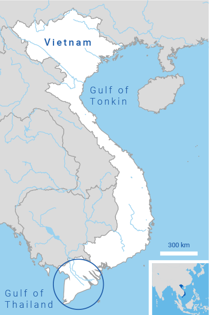
The Mekong River originates in the Himalayas and traverses China, Myanmar, Thailand, and Cambodia. At Phnom Penh, it divides into a main northern branch—called the Tien River after entering Vietnam—and a southern branch, called the Bassac River in Cambodia and the Hau River in Vietnam. They divide into six and three main channels respectively, reaching the sea in southern Vietnam.
The delta’s dense network of rivers and man-made canals covers 12 provinces and the municipality of Can Tho. Its total area of about 40,500 square kilometers represents 12 percent of Vietnam’s territory. The delta is home to 20 million people, or 18 percent of the country’s population, and accounts for 18 percent of its GDP. This includes 50 percent of the country’s rice production—close to 95 percent of its rice exports—along with 65 percent of fruit production and 70 percent of fisheries, another key export sector.
Almost all the delta’s rain falls between May and October. Flood dynamics are regulated through three natural reservoirs—the Tonle Sap (in Cambodia), the Long Xuyen Quadrangle, and the Plain of Reeds (both in Vietnam). The last two are vast flood plains, covering roughly 600,000 hectares and 700,000 hectares respectively, and holding water to a depth of three to four meters. They reduce the flooding impact downstream during the flood season, and balance salinity in the coastal zone during the dry season by releasing freshwater that supplements the Mekong flows.
The delta is divided into four hydro-ecological zones
- Upper delta flood plain: Suitable for rice production, fruit horticulture, and freshwater aquaculture. During the wet season, floodwater levels regularly exceed two meters.
- Middle delta: Characterized by industrialization, land use changes, and limited urban water supply and wastewater services.
- Delta estuary: Rice cultivation and brackish aquaculture are important, but mangrove forests are being destroyed as farmers convert them into shrimp farms.
- Delta peninsula: With limited freshwater sources, brackish aquaculture is the dominant land use.
The Mekong Delta, Vietnam
 The Mekong Delta faces the sea on both its east and west coast, and its tides are a defining trait far inland: they cause the rivers and canals to flow back and forth, once a day on the west coast and twice a day on the east coast, with a weekly cycle of spring tides and neap tides. The ‘flood pulse’ of alternating inundation and drought means the rivers and canals can purify themselves, depending on the strength of currents that flush away contaminants and the amount of dissolved oxygen in the water to decompose organic matter and break down inorganic toxins into less toxic compounds.
Climate change is increasing temperatures and making rainfall more variable, seriously affecting crop yields, human health, and the aquatic environment. Saltwater intrusion is projected to worsen with rising sea levels and land subsidence. Upstream, wetter wet seasons and drier dry seasons will result in more severe and frequent floods and droughts. Peat swamp forests help with flood control, but overexploitation for timber and non-timber forest products has led to increased water loss and fire risks.
Climate change is not the only factor affecting the delta’s development. In many areas, land subsidence is a major issue and reaches rates of between one and four centim- eters a year, a ten-fold sea-level rise106. And even though subsidence is not a direct climate-related issue, it is accel- erated due to the increasing extraction of groundwater to counter salt intrusion and combat increased droughts. Other influencing factors are: economic development (mainly rice cultivation, wild fisheries, aquaculture, and associated technological developments); demographic trends (aging populations and out-migration); urbanization; upstream activities (especially dam construction for hydro- power); and weaknesses in governance and institutional capacity, particularly related to transport of goods and people, infrastructure, and financial capital.
Operation of the basin’s hydropower reservoirs could exacerbate both floods and droughts: water is stored in the reservoirs during the dry season, potentially contributing to freshwater shortages, and released during storms, potentially making floods more dangerous. Another draw- back of hydropower reservoirs is that the sediments transported by rivers get trapped by the dams. This deprives the delta of its natural fertilizers and building materials, resulting in soil degradation and erosion of coasts and riverbanks.
Flooding: from blessing to threat
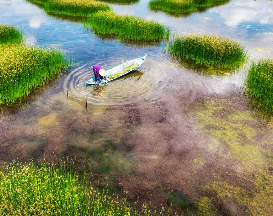
Flooding in the delta was historically seen as a natural process that maintains productivity: fertile silt is trans- ported downstream and deposited on the delta’s flood plains, while the floodwaters also carry sand, fish eggs, and fingerlings bred upstream. The delta’s population adapted their ways of life to avoid extensive damage and benefit from the valuable resources carried by the floodwater. Indeed, the term ‘flood season’ was not part of the vernacular and instead locals referred to a ‘water rising season,’ in which the water level would gradually and predictably rise.
After the reunification of Vietnam in 1975, however, this view changed. From being seen as a blessing, flooding started to be viewed as a threat to infrastructure and agriculture. At the end of the war, the country was starving. Consequently, the delta shouldered the role of providing food for the country and every effort was made in food production. The government pursed a self-sufficient food security strategy, the ‘rice first’ policy, to maximize rice production in the Mekong Delta—expanding the growing area, maximizing yields through chemical fertilizers and pesticides, and introducing ‘triple cropping.’ The third crop, planted during the flood season, requires high dikes to prevent sediment from entering the fields—but this also prevents the soils from naturally being replenished. Crop failures are common, especially in dry years.
This ‘rice first’ policy led to the construction of massive engineering infrastructure that disrupted the delta’s natural systems: high dikes in the flood plains; canals that drain away floodwater; sea dikes and coastal sluice gates to prevent saltwater intrusion into the inner delta; and water regulation projects to bring freshwater for rice cultivation to areas that were naturally saline. These systems often proved to underestimate the complexity of the ecology in the delta. Among the impacts have been:
![]() Displaced flooding and worsened salinity intrusion.
Displaced flooding and worsened salinity intrusion.
Dikes to control floods in the upstream provinces increased inundation in the downstream provinces. They significantly raised the levels of the rivers, exacerbating the erosion of riverbanks and the coast. Saltwater intrusion increased also during the dry season in the coastal provinces, for two reasons: (i) instead of entering the flood plains during the flood season for temporary storage, some floodwater is lost to the sea; and (ii) less freshwater is available during the dry season to supplement river flows and balance their salinity.
![]() Declining fishery resources.
Declining fishery resources.
The 'rice first' policy led to neglect of coastal fisheries, an important part of the delta’s economy. The flood plains, where fish eggs and fingerlings have traditionally grown are taken up by rice cultivation, in areas protected from floodwater by high dykes. Tens of thousands of sluice gates—which are shut during dry season to prevent saline intrusion—have disconnected the sea from inland waterways, resulting in slow-moving rivers without enough dissolved oxygen to support riverine fish.
![]() Increasing pressure on groundwater.
Increasing pressure on groundwater.
The growing pollution of surface water has caused an increase in groundwater extraction, especially for household purposes. According to the Ministry of Agriculture and Rural Development (MARD), 70-80 percent of the rural population
relied on groundwater in 2019. The water table in all aquifers has dropped since 1995. This increasingly causes land subsidence, particularly in the coastal areas of Ca Mau and Bac Lieu. A study by Utrecht University found that between 1991 and 2016, the delta’s annual subsidence due to groundwater extraction was between one and 4.7 centi- meters per year.
![]() Drought and salinity intrusion.
Drought and salinity intrusion.
Seasonal salinity of surface water affects about half of the delta, to varying degrees. During the wet season, much of its water becomes freshwater. During the dry season, it becomes saline again. Salinity penetrates inland up to 20-65 kilometers from the shore, varying from year to year, through the branches of the Mekong and the openings of smaller river mouths and canals. In extremely dry years, salinization can damage crops in areas usually not affected, resulting in drinking- water shortages, increased extraction of groundwater, and higher salinity levels in aquaculture ponds, which give rise to additional costs for farmers. Recent changes in salt- water intrusion and flooding in the delta have resulted from both climate change and damage to the delta’s natural systems. Current counter-measures, such as closing the barriers, has had many ecological and socio-economic consequences due to declining water quality, depleting fish stock and restricted river navigation.
![]() Poverty and loss of culture.
Poverty and loss of culture.
Rice intensification has failed to help the delta’s population escape poverty. According to MARD108, per capita income in the delta over the last decade has risen by less than the national average. Rice intensification has also changed the culture of the delta. Today, most village children do not even know how to swim—rivers and canals have become too contaminated by agricultural chemicals to bathe in. People fishing on rivers and canals is no longer a common sight because fish stocks have dropped sharply. According to MARD, the delta is the only region of Vietnam with net out-migration. Struggling to earn an income from agriculture, young people leave the area in search of employment in nearby cities or overseas.
The ‘Golden Policy Trio’ shifting to a nature-based approach
After the turn of the century, the government of Vietnam gradually came to realize that the policy of intensive rice cultivation, requiring massive water regulation infrastructure, is unsustainable and a course correction was needed to develop the delta in a more sustainable, climate-resilient way. The government started to diversify land use in the delta and promote a ‘living with floods’ approach in the inland provinces, seeing both freshwater and brackish waters as valuable resources.
This fundamental change in approach was catalyzed and supported by development partners through analytical studies and policy documents—notably the Mekong Delta Plan 2013, with a budget of around US$ 10 million, prepared with Dutch support—and investments, such as the Mekong Delta Climate Resilience and Sustainable Livelihoods Project, financed by the World Bank with an ongoing investment of US$ 387 million. It culminated in 2016 and 2017 with the government passing a ‘golden policy trio’ for the development of the Mekong Delta.
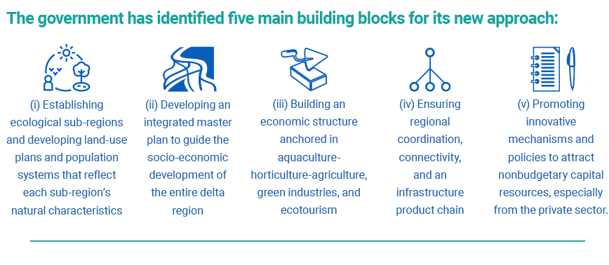
First came Decision 593 on coordinating activities for regional development across the provinces. Next the National Assembly passed a new Planning Law, which mandates a multidisciplinary, integrated approach to planning—a clear departure from the traditional sectoral and community-based approach, which often led to conflicts, overlapping efforts, unhealthy competition among provinces and sectors, and the fragmentation of natural systems.
Finally, the adoption of Resolution 120 enshrined the aim of sustainable and climate-resilient development in the delta, based on a comprehensive approach to building a more diverse, modern, and high-quality agricultural econ- omy, in harmony with nature and using the ‘no-regrets’ principle—selecting actions and investments that are cost-effective under a range of future climate scenarios, and do not involve hard trade-offs with other policy objectives.
Resolution 120 defines the long-term vision as: ‘A sustainable, safe and prosperous Mekong Delta, based on suitable development of high-quality agriculture products, combined with services, ecotourism and industries, focusing on manufacturing industry, enhancing the competitiveness of agriculture products; infrastructure network is coordinatedly planned, developed, modern in an active, smart way and adapting to climate change; ensuring safety under disaster; reasonable use of natural resources; biodiversity and cultural tradition is conserved and enhanced; human lives and spirit are improved.’
Implementing this trio of policies has so far brought some accomplishments, but also challenges. The need to embed land and water use and spatial planning in development policies is widely recognized, but sectors and provinces continue to be targeted separately. This is partly because of continuing lack of awareness of the new development policy approach among sectoral and provincial planners, and partly because there is no institution at regional level responsible for coordinating development.
Key lessons for delta management
The experience of the Mekong Delta over the last few decades offers four key lessons for deltas around the world.
1. Think of the delta as a living organism. Rivers, canals, and other water bodies are like its veins—the transportation channels for nutrients and energy. The tides, seasons, and flood pulse drive a circular system in which natural fluctuations of water levels provide alternating moist and dry conditions for soil organisms to respire and function. Higher levels of dissolved oxygen in the water of flowing rivers and canals gives them a natural capacity for self- purification, which is essential for maintaining the aquatic ecosystem: to some extent, rivers and canals need to flow freely to maintain the health of a delta.
2. Look beyond the economic rationale for the delta’s development. Ironically, the loss of sediments as a natural fertilizer and material for the natural delta building process, for example, may in fact boost GDP growth as it necessitates more application and sale of fertilizers and more construction of expensive embankments to combat increasing erosion. So using GDP as a sole indicator of the development of a delta is very unhealthy. The short-term boost given to the Mekong Delta’s GDP by intensive rice cultivation also came at the cost of long-term depletion of soils and waters. Development policies must look beyond benefits to identify costs, which are often hidden or not evident right away, and spatially and tempo- rally far-reaching.
3. Ensure integrated planning and regional coordination. Natural systems do not respect administrative boundaries, and the interests of sectors and communities can conflict. For example, in the Mekong Delta, sand mining in upstream provinces leads to coastal and riverbank erosion in down- stream provinces. The regional coordination mechanism provided by Decision 593 is intended to avoid such unhealthy competition, while pooling resources and creating synergies among provinces. Establishing a regional institution with the decision-making power to coordinate policies and actions—backed by sound scientific advice—is a precondition for regional coordination. The newly established (mid 2020) Mekong Delta Regional Coordination Council is expected to play this critical role.
4. Apply the ‘no-regrets’ principle in the planning for adaptation to climate change. No-regret actions are the opposite of ‘high-regret’ actions, which: (i) are expensive and irreversible; (ii) make other future options unfeasible; (iii) have adverse impacts on other geographic locations and/or sectors; and (iv) may be beneficial in the short term but detrimental in the long run. The no-regrets principle makes sense because of the many uncertainties inherent in climate change—the further into the future projections are made, the higher the margin of error—and the potential for adaptation actions to have adverse effects that may not be immediately clear.
Network Content
Network


Trending Discussions
From around the site...
“Absolutely interested! I'll connect via email to discuss reviewing and enhancing the Economic Analysis of Climate...”
Adaptation-related events at COP28 (all available to follow/stream online)
“Please check out these adaptation-related events taking place at COP28 - all available online (some in person too if...”
Shining a light for biodiversity – four perspectives to the life that sustains us. Four hybrid sessions.
“30 November to 19 December 2023 - Four Sessions Introduction The SDC Cluster Green is happy to invite you to the...”